There will likely be a significant storm system crossing the entire middle section of the U.S. in the second half of next week. Here are some travel suggestions to hopefully avoid a dangerous weather change while you are far away from home.
I have some travel timing tips for you. I do want to emphasize this storm is still six to seven days away from Michigan and the surrounding states. That is still a significant enough time to see considerable changes in the details of the weather. On the other hand, the model that does best in this situation hasn’t changed much over the past four days.
A large storm system will move across the Great Lakes and Ohio Valley next Thursday into Friday. Ahead of the storm system will be mild air and rain, especially for Illinois, Indiana, Ohio, Kentucky and Tennessee. Some part of southern Michigan may get into the mild air and the rain on the front of the storm. Where you get into rain, that’s a bad sign. The rain area will experience the rapid temperature drop and be the area I’m concerned for a flash-freeze. A flash-freeze is when the rain is continuing right up to the exact time of the rapid temperature drop.
My first tip is to realize this should be a significantly dangerous driving situation at some point next Thursday or Friday. So make sure you check my MLive updates through the weekend and early next week. I will continue to show you the changes in the timing and how the weather situation will play out.
My second tip- a really usable tip- is to start planning on leaving for your trip Wednesday, or even Tuesday afternoon or evening. Thursday could have a window of OK travel conditions, but you’ll be racing against a very strong arctic cold front. If you don’t win the race to your destination, your drive could wind up on an interstate turned ice skating rink. I think it’s a safer bet to get your travel companions ready to go Wednesday.
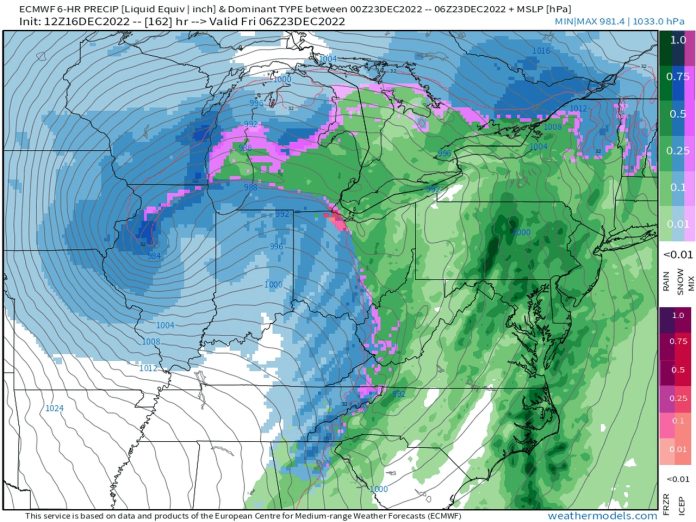
Here is the latest computer model run of the most accurate computer model, The European Medium Range Weather Forecast Model, also know as the ECMWF or the Euro for short. The forecast animation starts next Wednesday. You can definitely get a feel for the large-scale winter storm.
Surface weather forecast from 7 a.m. Wednesday, December 21 to 7 a.m. Christmas morning.
The track of the storm center will make all the difference in the world as to the weather scenario at a certain location. The northern half of Lower Michigan and the U.P. could be all snow for the entire storm. Southern Lower could warm up to get rain sometime Thursday, followed by a sharp temperature drop to temperatures well below freezing. It’s the southern part of Michigan that could get in on the flash-freeze. The flash-freeze is even more likely to our south in Illinois, Indiana, Ohio, Kentucky and Tennessee. Notice on the forecast animation the green-to-pink-to-blue area sweeping across areas to our south Thursday night and Friday. The change from rain to snow would be when the flash-freeze wold occur.
As the storm system moves east, Michigan and the surrounding states should have precipitation turn to all snow and continue through Friday. In fact, it’s possible for another inch or two of cold, fine snow to fall Saturday.
Friday will not be a good day to travel either with a much colder snow and strong winds producing blowing and drifting if the scenario doesn’t change.
To have the safest road conditions for driving next week, Monday, Tuesday and Wednesday will be the safest days. Thursday is probably a no-way type of traveling day unless you can drive a short distance in Michigan and beat the arrival of the arctic front and flash-freeze. Friday is also likely a no-way travel day if you don’t want to drive in accumulating snow that is blowing and drifting.
RELATED READING:
Dangerous flash-freeze highly possible as Arctic front passes through Michigan next week
See why Lower Michigan is the Banana Belt of the wintry Great Lakes
Lake Michigan, Lake Huron lose over 3 trillion gallons of water in November


