

During her journey along the Trent-Severn Waterway, Jenn McCallum saw several species at risk, including northern map turtles along the Trent River. (Photo: Jenn McCallum)
GreenUP encourages people to connect with nature and appreciate the health and history of local watersheds. This guest-authored story is the second in a series about a group of 16 friends (plus two dogs) from Peterborough who decided to paddle the Trent-Severn Waterway from the Odenaabe (Otonabee) River in the south end of Nogojiwanong (Peterborough) to the Bay of Quinte. One of the inspirations behind the trip was to connect with the watershed, its history, and the traditional migration of the Atlantic salmon along this route.
Paul Baines, who initiated the adventure and lives along the Otonabee River, wrote the first of this series of articles the week of May 11. The final article in this series will be released the week of June 29.
In the past, I have worked in water quality monitoring and as an environmental educator with both adults and children, inspiring and encouraging behaviours that enhance and restore our waterways. For example, planting native species of trees, shrubs, and wildflowers along our shorelines provides habitat for aquatic and avian species and reduces erosion.
With this professional history, I am always eager to learn more about the Otonabee and Trent River watersheds.
Advertisement – story continues below
I am also passionate about paddling and Ontario’s flora and fauna, so this paddling adventure was a perfect fit. I was able to join for nine of the 10 sections of the journey, my dog Blitz joined for eight of the sections, and my husband John for seven.
For others eager to paddle the Otonabee or Trent Rivers, I will share some travel tips and some observations of the natural features and species of these waterways.
For starters, one of the awe-inspiring features of this area is Ranney Gorge along the Trent River, part of Ferris Provincial Park in Campbellford. With its large suspension bridge, hiking trails, and camping, the park offers beautiful vistas of the river, where one can spot many bird species and occasionally a turtle.
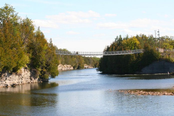 The Ranney Gorge suspension bridge along the Trent River is recognized as Ontario’s most scenic suspension bridge, and paddlers can also enjoy views of the cliffs from underneath the bridge. (Photo: Jenn McCallum)
We camped at the park for two nights and enjoyed its amenities, as well as visits to Dooher’s Bakery and a patio dinner at 52 North Pub and Grill. Along this stretch of the river, Campbellford Community Park is the best place to swim.
For boats of all shapes and sizes, navigating the Trent-Severn Waterway is a popular venture, and there are some options for camping on Parks Canada lands. At Locks 9 and 10 Parks Canada offers Ôasis pods — sleeping accommodations for two to four people that look like metal water drops on raised feet.
Parks Canada staff kindly let us peek inside one of these pods, and they look like they’d provide a comfortable sleep under the canopy of stars surrounded by the forest.
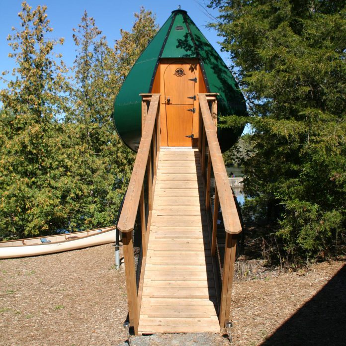 An Ôasis pod available for booking at the Parks Canada campsite at Locks 9 and 10 along the Trent-Severn Waterway. (Photo: Jenn McCallum)
Advertisement – story continues below
Boats navigating through the lock stations are required to pay a small fee based on the boat’s length. Canoeists and kayakers can pay to boat through the locks or can portage around them at no cost, but sometimes the portaging can be challenging, with steep banks and difficult put-ins. Some of the locks feature portaging docks to facilitate these take-outs and put-ins.
For any wildlife observer, these waterways are home to many floral and faunal species, including some considered at-risk in Ontario. There are three levels of species at risk designations: endangered (which means that the species is in imminent risk of extinction), threatened (where the species could become endangered if steps aren’t taken to protect it), and special concern (where a combination of biological characteristics and identified threats could lead to its population decline).
During our journey, we saw northern map turtles along the Trent River, a species of special concern provincially, and a bald eagle on Rice Lake, also special concern. Throughout the adventure, we observed many fish-eating species, including ospreys, great blue herons, a green heron, and occasionally northern water snakes peacefully sunning themselves or fishing for prey.
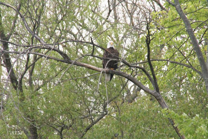 Jenn McCallum spotted this bald eagle, a species at risk, along the shores of Rice Lake. (Photo: Jenn McCallum)
Some of the plant species we saw were buttonbush, highbush cranberry, jewelweed and Joe-Pye weed, among many others. These plants and animals are important to the biodiversity and health of our waterways, and are a delight to observe!
One of our paddlers, Ian Attridge, noted, “The surrounding hills, points and islands provided scenic and historic backdrops to our journey. In the back wetland bays, we spied abundant fish, beautiful swamp milkweed, and little muskrat and beaver platforms. Diving ospreys and kingfishers and zooming dragonflies kept us entertained along the way!”
Unfortunately we also spotted the invasive yellow iris growing prolifically along the shores of the Indian River, where it can form dense mats and out-compete native shoreline plants (such as buttonbush and jewelweed).
Advertisement – story continues below
I recorded this observation of yellow iris on iNaturalist.org, a species observation platform, and tagged “Invasive Species in Ontario.” If you have observed invasive species, you can also log them in iNaturalist or call the Invading Species Hotline at 1-800-563-7711.
Overall, I was pleased to see that many of the shorelines were naturally vegetated with native species, stabilizing the soil, reducing erosion, and providing wildlife habitat.
For any cottage or shoreline property owner looking to help our waterways, you can plant native water-loving plants from GreenUP’s Ecology Park Nursery and I recommend checking out the Ontario Invasive Plant Council’s Grow Me Instead guide.
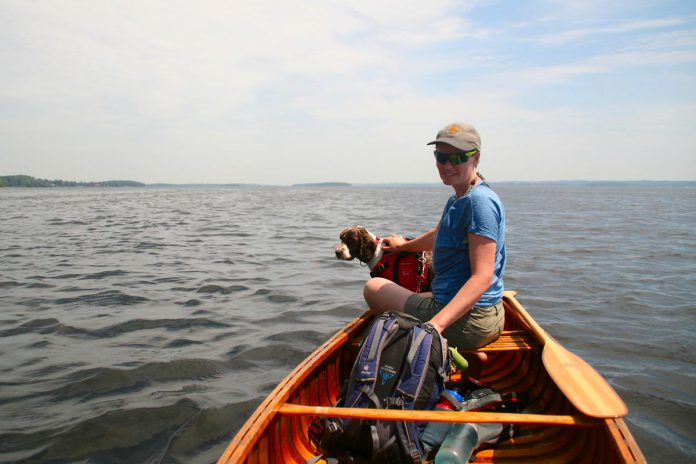 Jenn McCallum with her dog Blitz on Rice Lake on June 6, 2021, during a paddling trip a group of 16 friends from Peterborough took along the Trent-Severn Waterway from the Otonabee River in the south Peterborough to the Bay of Quinte. (Photo: Taylor Wilkes)
All in all, we were fortunate to complete this journey in good weather and in good health, and would certainly recommend exploring our local waterways to anyone interested in connecting with both human and wildlife communities.
In a few weeks we will share our final story in this series and you will hear more from others who took part about how these connections can shape and motivate us.
We hope you are inspired to find and maintain these connections through the summer and beyond.
Advertisement – story continues below
Links of interest
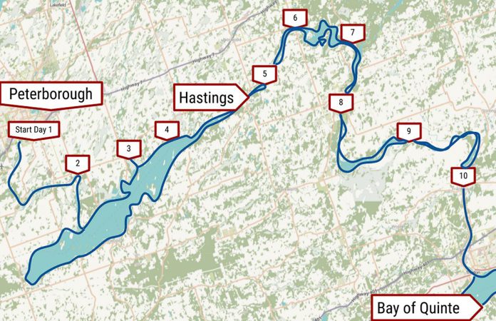 A map of the 10 daytrips 16 friends made to explore the route from Peterborough to the Bay of Quinte. (Graphic: Paul Baines / Open Street Maps)


